 README
README

![]()
go-staticmaps
A go (golang) library and command line tool to render static map images using OpenStreetMap tiles.
What?
go-staticmaps is a golang library that allows you to create nice static map images from OpenStreetMap tiles, along with markers of different size and color, as well as paths and colored areas.
go-staticmaps comes with a command line tool called create-static-map for use in shell scripts, etc.
How?
Installation
Installing go-staticmaps is as easy as
go get -u github.com/flopp/go-staticmaps
For the command line tool, use
go get -u github.com/flopp/go-staticmaps/create-static-map
Of course, your local Go installation must be setup up properly.
Library Usage
Create a 400x300 pixel map with a red marker:
import (
  "image/color"

  "github.com/flopp/go-staticmaps"
  "github.com/fogleman/gg"
  "github.com/golang/geo/s2"
)

func main() {
  ctx := sm.NewContext()
  ctx.SetSize(400, 300)
  ctx.AddMarker(sm.NewMarker(s2.LatLngFromDegrees(52.514536, 13.350151), color.RGBA{0xff, 0, 0, 0xff}, 16.0))

  img, err := ctx.Render()
  if err != nil {
    panic(err)
  }

  if err := gg.SavePNG("my-map.png", img); err != nil {
    panic(err)
  }
}
See GoDoc for a complete documentation and the source code of the command line tool for an example how to use the package.
Command Line Usage
Usage:
  create-static-map [OPTIONS]

Creates a static map

Application Options:
      --width=PIXELS       Width of the generated static map image (default: 512)
      --height=PIXELS      Height of the generated static map image (default: 512)
  -o, --output=FILENAME    Output file name (default: map.png)
  -t, --type=MAPTYPE       Select the map type; list possible map types with '--type list'
  -c, --center=LATLNG      Center coordinates (lat,lng) of the static map
  -z, --zoom=ZOOMLEVEL     Zoom factor
  -b, --bbox=NW_LATLNG|SE_LATLNG
                           Set the bounding box (NW_LATLNG = north-western point of the
                           bounding box, SW_LATLNG = southe-western point of the bounding
                           box)
  --background=COLOR       Background color (default: transparent)
  -u, --useragent=USERAGENT
                           Overwrite the default HTTP user agent string
  -m, --marker=MARKER      Add a marker to the static map
  -p, --path=PATH          Add a path to the static map
  -a, --area=AREA          Add an area to the static map

Help Options:
  -h, --help               Show this help message
General
The command line interface tries to resemble Google's Static Maps API.
If neither --bbox, --center, nor --zoom are given, the map extent is determined from the specified markers, paths and areas.
--background lets you specify a color used for map areas that are not covered by map tiles (areas north of 85°/south of -85°).
Markers
The --marker option defines one or more map markers of the same style. Use multiple --marker options to add markers of different styles.
--marker MARKER_STYLES|LATLNG|LATLNG|...
LATLNG is a comma separated pair of latitude and longitude, e.g. 52.5153,13.3564.
MARKER_STYLES consists of a set of style descriptors separated by the pipe character |:
color:COLOR- whereCOLORis either of the form0xRRGGBB,0xRRGGBBAA, or one ofblack,blue,brown,green,orange,purple,red,yellow,white(default:red)size:SIZE- whereSIZEis one ofmid,small,tiny, or some number > 0 (default:mid)label:LABEL- whereLABELis an alpha numeric character, i.e.A-Z,a-z,0-9; (default: no label)labelcolor:COLOR- whereCOLORis either of the form0xRRGGBB,0xRRGGBBAA, or one ofblack,blue,brown,green,orange,purple,red,yellow,white(default:blackorwhite, depending on the marker color)
Paths
The --path option defines a path on the map. Use multiple --path options to add multiple paths to the map.
--path PATH_STYLES|LATLNG|LATLNG|...
or
--path PATH_STYLES|gpx:my_gpx_file.gpx
PATH_STYLES consists of a set of style descriptors separated by the pipe character |:
color:COLOR- whereCOLORis either of the form0xRRGGBB,0xRRGGBBAA, or one ofblack,blue,brown,green,orange,purple,red,yellow,white(default:red)weight:WEIGHT- whereWEIGHTis the line width in pixels (defaut:5)
Areas
The --area option defines a closed area on the map. Use multiple --area options to add multiple areas to the map.
--area AREA_STYLES|LATLNG|LATLNG|...
AREA_STYLES consists of a set of style descriptors separated by the pipe character |:
color:COLOR- whereCOLORis either of the form0xRRGGBB,0xRRGGBBAA, or one ofblack,blue,brown,green,orange,purple,red,yellow,white(default:red)weight:WEIGHT- whereWEIGHTis the line width in pixels (defaut:5)fill:COLOR- whereCOLORis either of the form0xRRGGBB,0xRRGGBBAA, or one ofblack,blue,brown,green,orange,purple,red,yellow,white(default: none)
Examples
Basic Maps
Centered at "N 52.514536 E 13.350151" with zoom level 10:
$ create-static-map --width 600 --height 400 -o map1.png -c "52.514536,13.350151" -z 10
A map with a marker at "N 52.514536 E 13.350151" with zoom level 14 (no need to specify the map's center - it is automatically computed from the marker(s)):
$ create-static-map --width 600 --height 400 -o map2.png -z 14 -m "52.514536,13.350151"
A map with two markers (red and green). If there are more than two markers in the map, a good zoom level can be determined automatically:
$ create-static-map --width 600 --height 400 -o map3.png -m "color:red|52.514536,13.350151" -m "color:green|52.516285,13.377746"
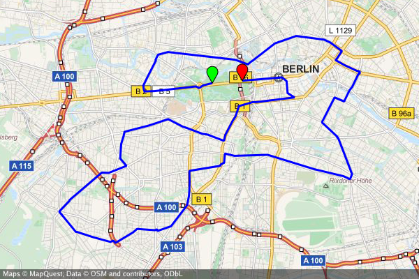
Create a map of the Berlin Marathon
create-static-map --width 800 --height 600 \
  --marker "color:green|52.5153,13.3564" \
  --marker "color:red|52.5160,13.3711" \
  --output "berlin-marathon.png" \
  --path "color:blue|weight:2|gpx:berlin-marathon.gpx"
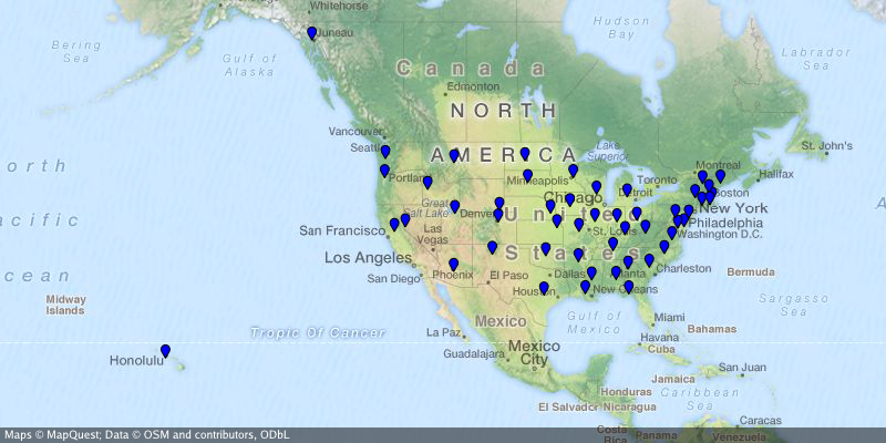
Create a map of the US capitals
create-static-map --width 800 --height 400 \
  --output "us-capitals.png" \
  --marker "color:blue|size:tiny|32.3754,-86.2996|58.3637,-134.5721|33.4483,-112.0738|34.7244,-92.2789|\
    38.5737,-121.4871|39.7551,-104.9881|41.7665,-72.6732|39.1615,-75.5136|30.4382,-84.2806|33.7545,-84.3897|\
    21.2920,-157.8219|43.6021,-116.2125|39.8018,-89.6533|39.7670,-86.1563|41.5888,-93.6203|39.0474,-95.6815|\
    38.1894,-84.8715|30.4493,-91.1882|44.3294,-69.7323|38.9693,-76.5197|42.3589,-71.0568|42.7336,-84.5466|\
    44.9446,-93.1027|32.3122,-90.1780|38.5698,-92.1941|46.5911,-112.0205|40.8136,-96.7026|39.1501,-119.7519|\
    43.2314,-71.5597|40.2202,-74.7642|35.6816,-105.9381|42.6517,-73.7551|35.7797,-78.6434|46.8084,-100.7694|\
    39.9622,-83.0007|35.4931,-97.4591|44.9370,-123.0272|40.2740,-76.8849|41.8270,-71.4087|34.0007,-81.0353|\
    44.3776,-100.3177|36.1589,-86.7821|30.2687,-97.7452|40.7716,-111.8882|44.2627,-72.5716|37.5408,-77.4339|\
    47.0449,-122.9016|38.3533,-81.6354|43.0632,-89.4007|41.1389,-104.8165"
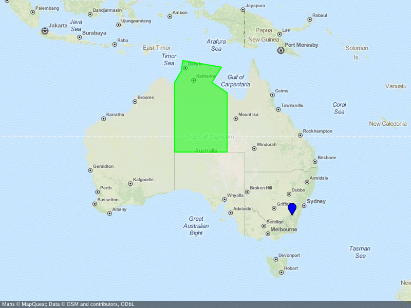
Create a map of Australia
...where the Northern Territory is highlighted and the capital Canberra is marked.
create-static-map --width 800 --height 600 \
  --center="-26.284973,134.303764" \
  --output "australia.png" \
  --marker "color:blue|-35.305200,149.121574" \
  --area "color:0x00FF00|fill:0x00FF007F|weight:2|-25.994024,129.013847|-25.994024,137.989677|-16.537670,138.011649|\
    -14.834820,135.385917|-12.293236,137.033866|-11.174554,130.398124|-12.925791,130.167411|-14.866678,129.002860"
Acknowledgements
Besides the go standard library, go-staticmaps uses
- OpenStreetMap, Thunderforest, OpenTopoMap, Stamen and Carto as map tile providers
- Go Graphics for 2D drawing
- S2 geometry library for spherical geometry calculations
- appdirs for platform specific system directories
- gpxgo for loading GPX files
- go-coordsparser for parsing geo coordinates
Contributors
- Kooper: fixed library usage examples
- felix: added more tile servers
- wiless: suggested to add user definable marker label colors
- noki: suggested to add a user definable bounding box
- digitocero: reported and fixed type mismatch error
- bcicen: reported and fixed syntax error in examples
- pshevtsov: fixed drawing of empty attribution strings
- Luzifer: added overwritable user agent strings to comply with the OSM tile usage policy
License
Copyright 2016, 2017 Florian Pigorsch & Contributors. All rights reserved.
Use of this source code is governed by a MIT-style license that can be found in the LICENSE file.
 Documentation
Documentation
Overview 
Package sm (~ static maps) renders static map images from OSM tiles with markers, paths, and filled areas.
Index 
- func CanDisplay(pos s2.LatLng) bool
- func CreateBBox(nwlat float64, nwlng float64, selat float64, selng float64) (*s2.Rect, error)
- func GetTileProviders() map[string]*TileProvider
- func Luminance(col color.Color) float64
- func ParseColorString(s string) (color.Color, error)
- type Area
- type Context
- func (m *Context) AddArea(area *Area)
- func (m *Context) AddMarker(marker *Marker)
- func (m *Context) AddPath(path *Path)
- func (m *Context) ClearAreas()
- func (m *Context) ClearMarkers()
- func (m *Context) ClearPaths()
- func (m *Context) GetTiles(cancel <-chan struct{}) (tiles <-chan Tile, zoom int)
- func (m *Context) Render() (image.Image, error)
- func (m *Context) RenderWithBounds() (image.Image, s2.Rect, error)
- func (m *Context) SetBackground(col color.Color)
- func (m *Context) SetBoundingBox(bbox s2.Rect)
- func (m *Context) SetCenter(center s2.LatLng)
- func (m *Context) SetSize(width, height int)
- func (m *Context) SetTileProvider(t *TileProvider)
- func (m *Context) SetUserAgent(a string)
- func (m *Context) SetZoom(zoom int)
- type MapObject
- type Marker
- type Path
- type Tile
- type TileFetcher
- type TileProvider
- func NewTileProviderCartoDark() *TileProvider
- func NewTileProviderCartoLight() *TileProvider
- func NewTileProviderOpenCycleMap() *TileProvider
- func NewTileProviderOpenStreetMaps() *TileProvider
- func NewTileProviderOpenTopoMap() *TileProvider
- func NewTileProviderStamenTerrain() *TileProvider
- func NewTileProviderStamenToner() *TileProvider
- func NewTileProviderThunderforestLandscape() *TileProvider
- func NewTileProviderThunderforestOutdoors() *TileProvider
- func NewTileProviderThunderforestTransport() *TileProvider
- func NewTileProviderWikimedia() *TileProvider
Constants 
This section is empty.
Variables 
This section is empty.
Functions 
func CanDisplay 
CanDisplay checks if pos is generally displayable (i.e. its latitude is in [-85,85])
func CreateBBox 
CreateBBox creates a bounding box from a north-western point (lat/lng in degrees) and a south-eastern point (lat/lng in degrees). Note that you can create a bounding box wrapping over the antimeridian at lng=+-/180° by nwlng > selng.
func GetTileProviders 
func GetTileProviders() map[string]*TileProvider
GetTileProviders returns a map of all available TileProviders
Types 
type Area 
type Area struct {
	MapObject
	Positions []s2.LatLng
	Color     color.Color
	Fill      color.Color
	Weight    float64
}
Area represents a area or area on the map
func ParseAreaString 
ParseAreaString parses a string and returns an area
type Context 
type Context struct {
	// contains filtered or unexported fields
}
Context holds all information about the map image that is to be rendered
func (*Context) ClearAreas 
func (m *Context) ClearAreas()
ClearAreas removes all areas from the Context
func (*Context) ClearMarkers 
func (m *Context) ClearMarkers()
ClearMarkers removes all markers from the Context
func (*Context) ClearPaths 
func (m *Context) ClearPaths()
ClearPaths removes all paths from the Context
func (*Context) GetTiles 
GetTiles requests a set of tiles, which will be sent over the returned channel. The channel will closed when all tiles have been returned.
func (*Context) Render 
Render actually renders the map image including all map objects (markers, paths, areas)
func (*Context) RenderWithBounds 
RenderWithBounds actually renders the map image including all map objects (markers, paths, areas) returned image covers requested area as well as any tiles necessary to cover that area, which may be larger than the request
Specific bounding box of as-returned image is provided to support image registratino with other data
func (*Context) SetBackground 
SetBackground sets the background color (used as a fallback for areas without map tiles)
func (*Context) SetBoundingBox 
SetBoundingBox sets the bounding box
func (*Context) SetTileProvider 
func (m *Context) SetTileProvider(t *TileProvider)
SetTileProvider sets the TileProvider to be used
func (*Context) SetUserAgent 
SetUserAgent sets the HTTP user agent string used when downloading map tiles
type MapObject 
type MapObject interface {
	// contains filtered or unexported methods
}
MapObject is the interface for all objects on the map
type Marker 
type Marker struct {
	MapObject
	Position   s2.LatLng
	Color      color.Color
	Size       float64
	Label      string
	LabelColor color.Color
}
Marker represents a marker on the map
func ParseMarkerString 
ParseMarkerString parses a string and returns an array of markers
func (*Marker) SetLabelColor 
SetLabelColor sets the color of the marker's text label
type Path 
Path represents a path or area on the map
func ParsePathString 
ParsePathString parses a string and returns a path
type Tile 
type Tile struct {
	image.Image       // Image is data in this tile
	s2.Rect           // Rect provides the Lat/Lng bounding box for this tile
	Err         error // Err reports any error attempting to retrieve this tile
}
Tile represents an image tile with an associated lat/lng boundign rectangle
type TileFetcher 
type TileFetcher struct {
	// contains filtered or unexported fields
}
TileFetcher downloads map tile images from a TileProvider
func NewTileFetcher 
func NewTileFetcher(tileProvider *TileProvider) *TileFetcher
NewTileFetcher creates a new Tilefetcher struct
func (*TileFetcher) Fetch 
func (t *TileFetcher) Fetch(zoom, x, y int) (image.Image, error)
Fetch download (or retrieves from the cache) a tile image for the specified zoom level and tile coordinates
func (*TileFetcher) SetUserAgent 
func (t *TileFetcher) SetUserAgent(a string)
SetUserAgent sets the HTTP user agent string used when downloading map tiles
func (*TileFetcher) ToggleCaching 
func (t *TileFetcher) ToggleCaching(enabled bool)
ToggleCaching enables/disables caching
type TileProvider 
type TileProvider struct {
	Name        string
	Attribution string
	TileSize    int
	URLPattern  string // "%[1]s" => shard, "%[2]d" => zoom, "%[3]d" => x, "%[4]d" => y
	Shards      []string
}
TileProvider encapsulates all infos about a map tile provider service (name, url scheme, attribution, etc.)
func NewTileProviderCartoDark 
func NewTileProviderCartoDark() *TileProvider
NewTileProviderCartoDark creates a TileProvider struct for Carto's tile service (dark variant)
func NewTileProviderCartoLight 
func NewTileProviderCartoLight() *TileProvider
NewTileProviderCartoLight creates a TileProvider struct for Carto's tile service (light variant)
func NewTileProviderOpenCycleMap 
func NewTileProviderOpenCycleMap() *TileProvider
NewTileProviderOpenCycleMap creates a TileProvider struct for OpenCycleMap's tile service
func NewTileProviderOpenStreetMaps 
func NewTileProviderOpenStreetMaps() *TileProvider
NewTileProviderOpenStreetMaps creates a TileProvider struct for OSM's tile service
func NewTileProviderOpenTopoMap 
func NewTileProviderOpenTopoMap() *TileProvider
NewTileProviderOpenTopoMap creates a TileProvider struct for opentopomap's tile service
func NewTileProviderStamenTerrain 
func NewTileProviderStamenTerrain() *TileProvider
NewTileProviderStamenTerrain creates a TileProvider struct for stamens' 'terrain' tile service
func NewTileProviderStamenToner 
func NewTileProviderStamenToner() *TileProvider
NewTileProviderStamenToner creates a TileProvider struct for stamens' 'toner' tile service
func NewTileProviderThunderforestLandscape 
func NewTileProviderThunderforestLandscape() *TileProvider
NewTileProviderThunderforestLandscape creates a TileProvider struct for thundeforests's 'landscape' tile service
func NewTileProviderThunderforestOutdoors 
func NewTileProviderThunderforestOutdoors() *TileProvider
NewTileProviderThunderforestOutdoors creates a TileProvider struct for thundeforests's 'outdoors' tile service
func NewTileProviderThunderforestTransport 
func NewTileProviderThunderforestTransport() *TileProvider
NewTileProviderThunderforestTransport creates a TileProvider struct for thundeforests's 'transport' tile service
func NewTileProviderWikimedia 
func NewTileProviderWikimedia() *TileProvider
NewTileProviderWikimedia creates a TileProvider struct for Wikimedia's tile service