 README
README
Cartesian API
![]()
![]()
![]()
Cartesian API for spatial data processing using geometry techniques to search points in 2d plane.
Summary
Quick-start
The only configuration needed is to create the .env file.
There is a .env-example that is ready to use, you can just rename it.
Use command below to run the API:
> make run
> make logs
To see all commands available:
> make help
Structure
├── data          // API data
├── devops        // Docker related files
├── handlers      // API endpoints
├── libs          // Utilities with no business logic
├── middlwares    // Custom middlewares
├── services      // Business logic as services
├── storage       // Storage interface and implementations
├── .env-example  // Template to create .env file
├── api.go        // Main entrypoint
└── Makefile      // Commands build, run ...
Techniques
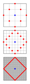
|
Blue: searched point |
| Red: searched distance | |
| Square: all points inside a spatial index |
Taxicab circle is a set of points that forms a square with a fixed Manhattan distance.
Using MySQL MBR (minimum bounding rectangles) functions we are capable to take advantage of spatial indexes.
SELECT x, y
FROM point, (
  SELECT
    # Taxicab circle (in red in the image)
    POLYGON(
      LINESTRING(
        POINT(x, y+d),
        POINT(x+d, y),
        POINT(x, y-d),
        POINT(x-d, y),
        POINT(x, y+d)
      )
    ) AS circle
	FROM (
		SELECT
			:x AS x,
			:y AS y,
			:distance +1e-9 AS d
	) params
) taxicab
# Filter entire square using index
WHERE MBRCONTAINS(taxicab.circle, point)
# Filter only point inside Manhattan/taxicab circle
AND ST_CONTAINS(taxicab.circle, point)
Firstly filter points inside square using index later filter only inside Manhattan distance.
According to MySQL documentation if there is too many rows inside the filtered data subset the index will not be used, so there is a fallback:
SELECT a.x, a.y
FROM point a, (
		SELECT
			:x AS x,
			:y AS y,
			:distance +1e-9 AS d
) b
# Manhattan distance: |x1-x2| + |y1-y2|
WHERE ABS(a.x-b.x)+ABS(a.y-b.y) <= d
# Use primary key (x, y)
AND a.x BETWEEN b.x-d AND b.x+d
AND a.y BETWEEN b.y-d AND b.y+d
Storage
The API was designed to accept any kind of storage system.
This is configurable in .env file using API_STORAGE_TYPE.
There are two storage types implemented:
- Memory: Small datasets.
- MySQL: Large datasets.
Services define their needs through interfaces and sub-packages of storage package will be responsible to implement these definitions.
// services/points/storage.go
package points

// [...]

type Storage interface {
	LoadPoints(reader io.ReadSeeker) error
	GetPointsByDistance(point model.Point, distance int) ([]model.RelativePoint, error)
}

// storage/storage.go
package storage

import (
	// [...]
	"github.com/jccatrinck/cartesian/services/points"
	// [...]
)

type Storage interface {
	points.Storage
}
Memory storage benchmark
BenchmarkPure: simple loop through all pointsBenchmarkGetPointsByDistance: find nearest X and Y using divide and conquer and filter distance of a small subset.
Total points: 100k
goos: linux
goarch: amd64
pkg: github.com/jccatrinck/cartesian/storage/memory
BenchmarkPure
BenchmarkPure-2                         85       37342004 ns/op        21.2 distance/op
BenchmarkGetPointsByDistance
BenchmarkGetPointsByDistance-2         258       12802766 ns/op        24.3 distance/op
Testing
In testing stage we create a entire environment using Docker compose to test everything.
There is no configuration needed and can be done using command below:
> make test
Handlers
Accept and respond with JSON.
Authentication Header
Authorization: Bearer ${API_KEY}
*If API_KEY is empty authentication will be disabled
Response codes
List points
List points inside a distance
Endpoint : GET /points?distance={number}&x={number}&y={number}
Payload : N/A
Response : []RelativePoints
Example response:
[
   {
      "x": 84,
      "y": -34,
      "distance": 1
   }
]
Future work
Use redis in memory storage type.
Deploy to the cloud using Terraform within the CD pipeline with Google App Engine and Google Cloud SQL.
Build a React front-end interface to interact with API.
 Documentation
Documentation

There is no documentation for this package.